
Bentonville ZIP Coverage Map
Two named USPS delivery areas form the familiar Bentonville mailing pattern, while five Census ZCTAs touch the incorporated city polygon. ZCTA means ZIP Code Tabulation Area, a Census approximation built for statistics rather than mail delivery. The distinction prevents a postal label from being used as false proof of city jurisdiction.
| ZIP | Areas Covered | Post Office | Notes |
|---|---|---|---|
| 72712 | Historic and core named Bentonville delivery area | Bentonville Post Office, 1706 S. Walton Blvd. | Named Bentonville postal area |
| 72713 | Southwest growth area split from 72712 | Verify through USPS | New delivery area effective July 1, 2018 |
| 72714 | ZCTA touches the city near the Bella Vista edge | Address-level verification | Not a Bentonville-named delivery area |
| 72715 | ZCTA touches the municipal polygon near Bella Vista | Address-level verification | Census area is not the city line |
| 72756 | ZCTA reaches the city near the Rogers edge | Address-level verification | Postal city may differ from jurisdiction |
This Bentonville ZIP code directory includes every intersecting ZCTA because each can appear in a citywide data extract. It does not imply that every address in those five broad areas belongs to Bentonville. Use a full street address for the final test.
Two Bentonville Codes, Five ZCTAs
The phrase “Bentonville ZIPs” has two valid meanings. USPS names 72712 and 72713 for Bentonville delivery. Census geography shows 72714, 72715, and 72756 also intersecting the incorporated polygon. The first meaning helps with mail. The second helps interpret Census tables and mapped data.
Census data for Bentonville identifies the intersecting ZCTAs, but the city GIS remains the better source for the municipal line. A parcel near Bella Vista or Rogers can therefore carry one geographic label in a data table and another jurisdiction in the legal parcel record.
Boundary rule. Use USPS for deliverability, city GIS for incorporation, and the assessor for the parcel's physical and legal identity.
Bentonville 72713 Began in 2018
Rapid southwest growth led USPS to create 72713 from part of 72712, effective July 1, 2018. The initial USPS announcement described 7,910 residential and 132 business addresses. The final bulletin gave 7,134 deliveries. Those are different measures from different notices, not numbers to merge.
The captured USPS release marks the change that reshaped Bentonville's modern postal areas.
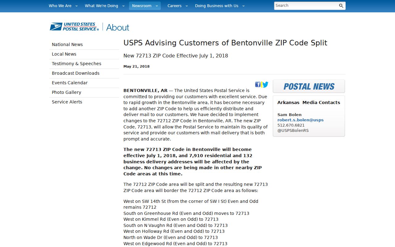
The effective date explains why an older Bentonville record may show 72712 for an address that now verifies as 72713.
The implementation bulletin is the second official source for the change.
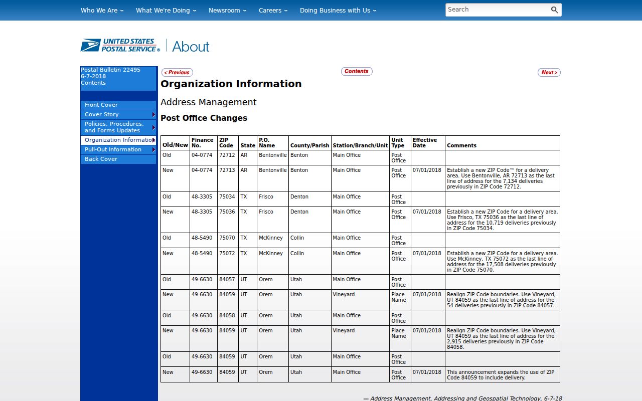
For a person search, preserve the code printed on the dated source and also test the address under its current delivery code.
Verify Bentonville Postal Addresses
The Bentonville Post Office at 1706 S. Walton Boulevard serves as the local postal contact and lists 479-273-2722. USPS address tools are the authority for current delivery format. They can resolve whether a full address uses 72712 or 72713, but they do not decide if the parcel lies inside the incorporated city.
The manifest capture records the USPS location page used to check the local postal channel.
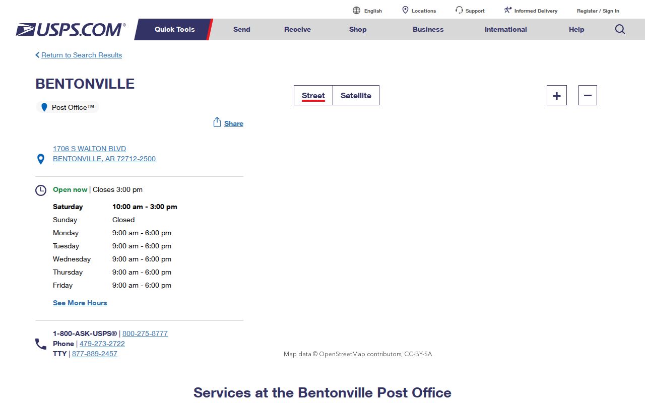
The office listing supplies postal contact context; parcel and city GIS sources still control the nonpostal parts of the search.
No official source inspected verified a unique or PO-box-only Bentonville postal code. It would be inaccurate to add one from an informal web list. Verify the complete address instead.
Search Bentonville Residents by ZIP
A postal area can narrow a large name set, but the order of operations matters. Begin with a verified full address or a known parcel clue. Then use the relevant public roll. The ZIP is a filter, not evidence that every result belongs to the same neighborhood or city.
- Verify the full delivery address with USPS, keeping the historical code if it appears on an older source.
- Search Benton County GIS or the assessor. Record the parcel's situs city and postal field separately from the owner's mailing address.
- Use a lawful voter-file extract by residence ZIP or precinct when that record set fits the question. Do not try to turn VoterView into a browseable roll.
- Confirm incorporation with the city boundary before calling a result a Bentonville resident.
- Once the result set narrows to a road, continue with the Bentonville street directory for the address-level chain.
Owner, registered voter, and occupant remain different roles. Date each source, especially in southwest Bentonville where the postal split and fast growth can make an old record look inconsistent with a current one.
Bentonville Parcel ZIP Fields
The Benton County parcel app offers address, parcel, plat, street, subdivision, section-map, and rural-scan searches. An address match returns the full address, number, direction, road, type, suffix, unit, city, and ZIP. A parcel match adds owner, parcel ID, acres, section-township-range, subdivision, and an assessor link.
| Search Route | Input | Useful Result for Postal Work |
|---|---|---|
| Address | Full or partial address | Direction, road, unit, city, and ZIP |
| Parcels | Parcel ID, owner, or address | Owner, parcel, situs, subdivision, assessor link |
| Streets | Street-name text | Road name, highway number, ownership |
| Subdivisions | Subdivision name | Mapped subdivision identity |
| Spatial | Buffer and target layer | Intersecting or contained mapped records |
The assessor's basic interface also accepts parcel number, parcel type, owner name, street number, direction, street name, exact spelling, and city. Its mailing fields describe the owner's contact destination. They must not be confused with the property's situs postal field.
The city GIS Coordinator or designee assigns street names and addresses, keeps the authoritative GIS Master Map, and resolves conflicts. Bentonville code bars duplicate or phonetically similar road names and calls for aligned streets to keep one name. That local control explains why the city map is the right place to resolve a questionable street label, while USPS remains the right place to confirm the mail form. A deed adds a third layer: its legal description follows a lot, block, subdivision, or metes-and-bounds tract even when the delivery label changes.
Read Bentonville Street Sides
Bentonville's street GIS stores left-from, left-to, right-from, and right-to address ranges, plus direction, street type, postal city, optional ZIP, and left or right venue values. Opposite sides of one road can therefore carry distinct attributes. This is more precise than assigning a whole street to one broad area.
The city street GIS layer exposes the actual field schema behind that distinction.
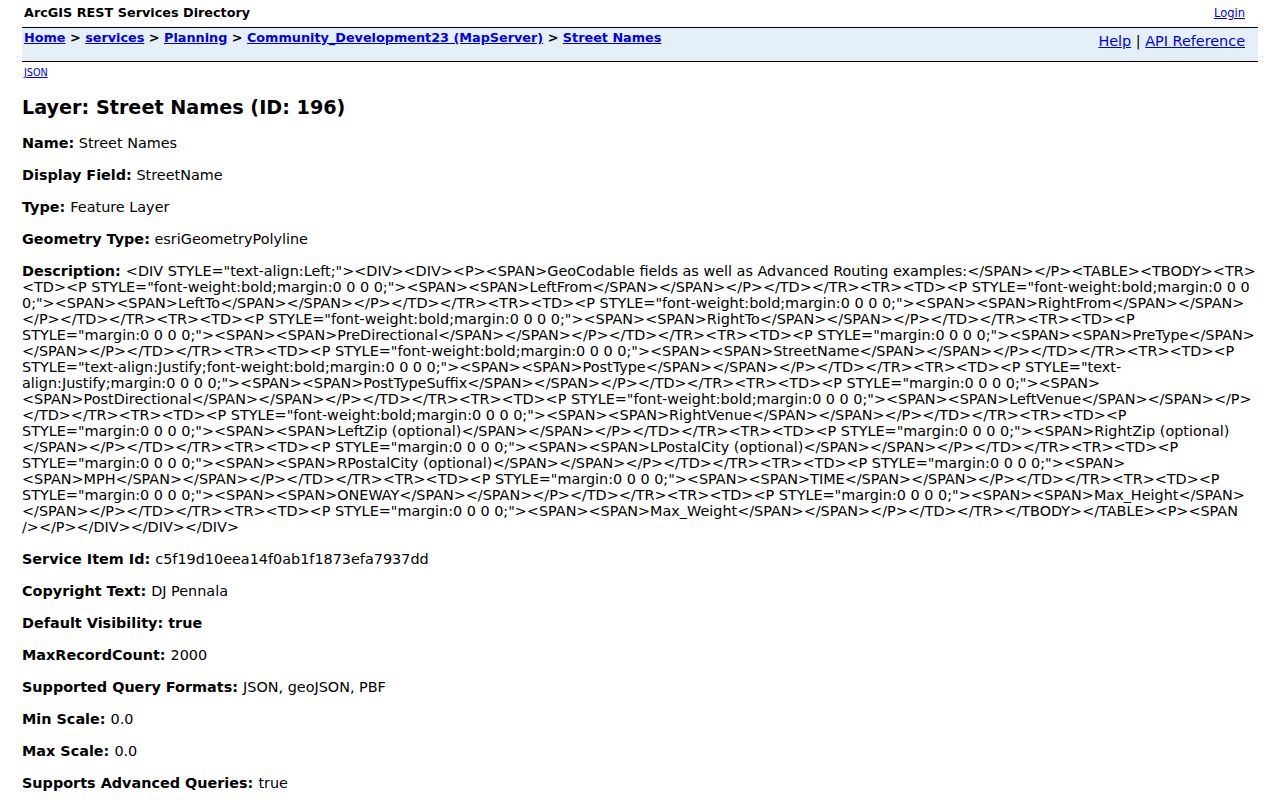
The left and right ranges help test an address segment, yet an individual parcel remains the strongest unit for tying postal and city geography together.
Directional prefixes are essential in Bentonville. A number and street name without NW, NE, SW, or SE can point to the wrong place. Preserve the full normalized address in every search.
Sort Bentonville Voter Files
VoterView is an individual identity lookup requiring first name, last name, and date of birth. It cannot browse all people in a postal area. A broader lawful question uses the Secretary of State data request or the Benton County Clerk's statutory file process.
Ark. Code Ann. § 7-5-109 provides an electronic registered-voter list that excludes secure-voter addresses and includes at least name, address, and precinct. The documented state file includes residential or mailing address, county, precinct, districts, and other controlled fields. Sorting by residence ZIP can describe registered voters in that slice, not every adult or household.
The county clerk's maximum electronic fees are $10 for up to 5,000 records, $25 for 5,001 through 25,000, and $50 above that range. A printed list is capped at two cents per name and address. Those figures come from the statute, while the Secretary of State's current delivery method and price should be confirmed before ordering. Keep secure-voter exclusions intact, and retain only the fields needed for the lawful research question.
Note: Voter participation history can show that a listed election was joined, but never how any ballot was marked.
Bentonville ZIPs Versus City Limits
Municipal annexations and postal revisions happen under different systems. Bentonville GIS records annexation years including 1887, 1954, 1972 through 1974, and 1979 through 2021. A later annexation does not force USPS to redraw its delivery geography, and a postal split does not annex land. That is why northern and eastern edges, plus the Bella Vista and Rogers sides, require a parcel-level check.
- ZIP and ZIP+4
- A five-digit delivery area and a four-digit extension that narrows a delivery segment.
- PO-box ZIP
- A code assigned chiefly to post-office boxes. None was verified as Bentonville-only in the inspected sources.
- Unique ZIP
- A code assigned to one high-volume organization. None was verified for Bentonville.
- Carrier route
- A postal delivery path within a broader code, not a city or neighborhood boundary.
- ZCTA
- A Census statistical approximation of postal geography, not an official USPS delivery boundary.
This mismatch is the central caution in any Bentonville postal directory. Use the mailing code to find the address, then the mapped parcel to identify city jurisdiction.
Date Bentonville Postal Matches
Bentonville grew from 54,164 residents at the 2020 Census to an estimated 63,057 on July 1, 2025. That pace changes delivery points, subdivisions, parcel records, permits, and voter addresses quickly. A name tied to one code in an older directory may have moved, or the address may simply have changed postal codes in 2018.
Older downtown and nearby historic areas may need a plat, Sanborn sheet, directory, or newspaper to bridge an earlier address form. New west and southwest development is more likely to appear in current subdivision plats, permit layers, and present-day GIS. At northern and eastern edges, an annexation layer is often more useful than a mailing-city label. The source mix should follow the age and location of the address instead of forcing one postal method across all of Bentonville.
Keep the source date beside the full address. Separate the physical parcel, owner-mailing destination, postal city, and municipal boundary. When those facts disagree, do not pick the most convenient label. Check each with the agency that maintains it.
Use postal data with care. A broad Bentonville code is a search filter, not permission to identify, contact, or target people within it.